


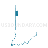
WASHINGTON, Newton County, Indiana
About
Outline

Summary
| Unique Area Identifier | 579897 |
| Name | WASHINGTON |
| County | Newton County |
| State | Indiana |
| Area (square miles) | 45.88 |
| Land Area (square miles) | 45.88 |
| Water Area (square miles) | 0.00 |
| % of Land Area | 100.00 |
| % of Water Area | 0.00 |
| Latitude of the Internal Point | 40.86737600 |
| Longtitude of the Internal Point | -87.45656320 |
Maps


Graphs
Select a template below for downloading or customizing gragh for WASHINGTON, Newton County, Indiana


Neighbors
Neighoring Voting District (by Name) Neighboring Voting District on the Map
- BEAVER Voting District, Iroquois County, IL
- BEAVER 01, Newton County, IN
- BEAVER 02, Newton County, IN
- CONCORD Voting District, Iroquois County, IL
- IROQUOIS 01, Newton County, IN
- IROQUOIS 02, Newton County, IN
- JACKSON, Newton County, IN
- JEFFERSON 01, Newton County, IN
- JEFFERSON 02, Newton County, IN
Top 10 Neighboring County Subdivision (by Population) Neighboring County Subdivision on the Map
- Jefferson township, Newton County, IN (2,140)
- Beaver township, Newton County, IN (1,573)
- Iroquois township, Newton County, IN (1,358)
- Beaver township, Iroquois County, IL (527)
- Concord township, Iroquois County, IL (466)
- Jackson township, Newton County, IN (382)
- Washington township, Newton County, IN (322)
Top 10 Neighboring Elementary School District (by Population) Neighboring Elementary School District on the Map
Top 10 Neighboring Secondary School District (by Population) Neighboring Secondary School District on the Map
Top 10 Neighboring Unified School District (by Population) Neighboring Unified School District on the Map
- North Newton School Corporation, IN (9,235)
- South Newton School Corporation, IN (5,190)
- Donovan Community Unit School District 3, IL (2,228)
Top 10 Neighboring State Legislative District Lower Chamber (by Population) Neighboring State Legislative District Lower Chamber on the Map
- State House District 79, IL (115,123)
- State House District 105, IL (109,839)
- State House District 15, IN (69,617)
Top 10 Neighboring State Legislative District Upper Chamber (by Population) Neighboring State Legislative District Upper Chamber on the Map
- State Senate District 53, IL (226,526)
- State Senate District 40, IL (220,404)
- State Senate District 6, IN (146,652)
Top 10 Neighboring 111th Congressional District (by Population) Neighboring 111th Congressional District on the Map
Top 10 Neighboring Census Tract (by Population) Neighboring Census Tract on the Map
- Census Tract 1005, Newton County, IN (3,260)
- Census Tract 9501, Iroquois County, IL (2,940)
- Census Tract 1006, Newton County, IN (2,706)
- Census Tract 1007, Newton County, IN (2,301)